


SwitzerlandMobility
คำอธิบายของSwitzerlandMobility
แอพ SwitzerlandMobility เป็นเพื่อนที่สมบูรณ์แบบสำหรับทุกคนที่ชอบออกไปข้างนอก ไม่ว่าจะเป็นในฤดูร้อนหรือฤดูหนาว
ค้นพบเส้นทางใหม่ รับแรงบันดาลใจ และวางแผนและนำทางประสบการณ์ของคุณ
ค้นพบเส้นทางที่น่าสนใจที่สุดในสวิตเซอร์แลนด์
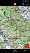
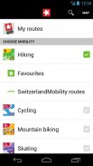
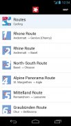
แอป SwitzerlandMobility นำเสนอการเข้าถึงเส้นทางที่น่าหลงใหลที่สุด 1,500 เส้นทางในสวิตเซอร์แลนด์และอาณาเขตของลิกเตนสไตน์ ในฤดูร้อน กิจกรรมดังกล่าวรวมถึงการเดินป่า ขี่จักรยาน ปั่นจักรยานเสือภูเขา สเก็ต และพายเรือแคนู ในฤดูหนาว คุณจะพบกับเส้นทางเดินป่าในฤดูหนาว เส้นทางรองเท้าเดินหิมะ เส้นทางสกีวิบาก และทางเลื่อนหิมะ เครือข่ายเส้นทางพร้อมใช้งานสำหรับคุณในแผนที่คุณภาพสูงสุดพร้อมแผนที่ระดับชาติจาก swisstopo สูงสุดถึงมาตราส่วน 1:10,000
การวางแผนทัวร์อย่างง่าย
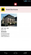
คุณจะพบคำอธิบายอย่างละเอียดและรายงานภาพถ่ายโดยละเอียดสำหรับแต่ละเส้นทาง สิ่งนี้จะช่วยให้คุณมีความคิดที่ดีเกี่ยวกับสิ่งที่คาดหวังได้จากไซต์ จุดจอดขนส่งสาธารณะ รวมถึงเวลาออกเดินทางครั้งถัดไปพร้อมลิงก์โดยตรงไปยังแอป SBB ตลอดจนข้อมูลเพิ่มเติมมากมายเกี่ยวกับตัวเลือกที่พัก สถานที่ท่องเที่ยว จุดแวะพัก จักรยานให้เช่า และสถานีบริการจักรยาน ทำให้การเตรียมการเดินทางของคุณเป็นเรื่องง่าย
เดินทางปลอดภัย
เส้นทาง SwitzerlandMobility เป็นทางการและมีป้ายบอกทางในพื้นที่ การปิดเส้นทางและการผันเส้นทางปัจจุบันก็มีอยู่ในแอปเช่นกัน ข้อมูลมีการอัปเดตทุกวัน ดังนั้นคุณจึงมีรายละเอียดล่าสุดอยู่ตลอดเวลา
คุณสมบัติการติดตามตำแหน่งและเข็มทิศ
คุณสามารถค้นหาเส้นทางที่ถูกต้องได้ตลอดเวลาด้วยแอป SwitzerlandMobility คุณสามารถดูตำแหน่งของคุณบนแผนที่ได้อย่างง่ายดายด้วยการติดตามตำแหน่ง คุณลักษณะเข็มทิศจะจัดตำแหน่งแผนที่ในทิศทางที่คุณกำลังมองหา เพื่อให้คุณสามารถติดตามการเดินทางที่วางแผนไว้ได้
วางแผนทัวร์ของคุณเอง
วางแผนทัวร์ของคุณเองบนแผนที่ swisstopo ระยะทาง การขึ้นและลง โปรไฟล์ระดับความสูง และเวลาที่ต้องการจะถูกคำนวณโดยอัตโนมัติ คุณลักษณะนี้มีให้สำหรับคุณด้วย SwitzerlandMobility Plus (มีค่าใช้จ่าย)
ใช้แอพโดยไม่ต้องรับสัญญาณเครือข่าย
ทัวร์ที่วางแผนไว้ ส่วนแผนที่ และข้อมูลเส้นทางทั้งหมดมีให้ใช้งานแบบออฟไลน์ในแอป เหมาะสำหรับภูมิประเทศแบบเทือกเขาแอลป์ที่ไม่มีสัญญาณเครือข่าย บันทึกส่วนแผนที่ด้วยเนื้อหาที่คุณเลือก คุณลักษณะนี้มีให้สำหรับคุณด้วย SwitzerlandMobility Plus (มีค่าใช้จ่าย)
บันทึกทัวร์ของคุณเองในแอป
ด้วย SwitzerlandMobility Plus คุณสามารถบันทึกการเดินทางของคุณลงในแอปได้โดยอัตโนมัติ ข้อมูลนี้จะทำให้คุณเห็นภาพรวมของข้อมูลที่สำคัญทั้งหมด เช่น ระยะทาง ระดับความสูงที่ครอบคลุม และเวลาที่ต้องการ คุณสมบัตินี้มีให้สำหรับคุณด้วย SwitzerlandMobility Plus (มีค่าใช้จ่าย)
ค้นหาข้อมูลเพิ่มเติมเกี่ยวกับข้อดีและคุณสมบัติเพิ่มเติมของ SwitzerlandMobility Plus: www.switzerlandmobilty.ch/de/switzerlandmobility-plus
SwitzerlandMobility--เวอร์ชั่น5.4.0
(14-04-2025)SwitzerlandMobility - ข้อมูล APK
เวอร์ชั่น APK: 5.4.0แพ็คเกจ: ch.schweizmobilเวอร์ชั่นล่าสุดของSwitzerlandMobility
เวอร์ชั่นอื่น


แอปในประเภทเดียวกัน


